Erdigg Cycle Rides

Erddig is owned by the National Trust, to whom it was bequeathed by the last Squire, Philip Yorke. The Yorke family maintained a fascinating collection of portraits and photographs of people who worked on the estate. Outside there is a formal garden and landscaped park.

It is possible to do a short ride completely within the grounds. However, the ride can easily be extended along the quiet country lanes surrounding Erddig. You can hire cycles, including tandems, for very reasonable rates. The last time we went we hired a tandem for two of our children, which they really enjoyed riding. The cycle hire shop is within the property itself, so if you are not a National Trust member, you will have to pay to access the shop. However, you could also take the opportunity to look round the house and formal gardens. The park land surrounding the formal gardens is freely accessible, so if you bring your own bikes you can do the rides without paying to enter the house.

The hire shop has a leaflet which shows a couple of rides of about 3 miles through the grounds and along the local lanes. We did both these one after the other on a sunny day.

Llyn Brenig

Llyn Brenig is a man made reservoir situated in a large area of moorland between Denbigh and the A5. There a many possible rides in this area. The one described is a circuit of the lake and is approximately 10 miles long. There is a short section along a B road, but this isn't normally busy. The ride is described going round the lake in an anticlockwise direction, as route finding is easier this way.

From the Visitor Centre find the track that runs in a southerly direction along the side the reservoir. It starts opposite the cycle hire place. Cycle over the dam and follow the stone track along the reservoir. This leads through a short section of forest and finally onto a small lane. Follow the lane to the junction with the B4510 ad turn left onto the road.

This is where the uphill section starts! It isn't too steep but is fairly continuous. Eventually you reach the summit, where the map shows a parking place with picnic table. In April 2010 the table wasn't there, but the parking place is a good place to admire the view and recover from the climb.

There is now a nice downhill section, which leads to a T junction. Turn left and take the second forestry track on the left (the first one leads to a dead end). This descends down to the reservoir, where you can follow the shore back to the Visitor Centre. Be careful not to take any turns leading off to the right as these will lead you back to the B4501.

You can download a PDF showing the route taken by this ride from here . There are details of other cycle rides on the ridehiraethog web site.

The Visitor Centre is open seven days a week between March and the end of October. There is a good cafe and an and outside play area for the children. They can be contacted on 01490 420463 or you can view their web site by clicking here .

Meindl Softline Ultra Boots

Normally I go walking either in my trainers, or in a cheap and comfortable pair of hi-Tec boots. However, this summer we had decided to visit the Dolomites and I wanted something that I could use on the Via Ferrata's. Whilst my Hi-Tec boots have been really comfortable for walking, the soles are very bendy and not suitable for climbing.

I wandered into Cotswold's Chester store with the intention of buying a pair of Asolo Flame GTX boots. However, after trying a few pairs on I found that they were a bit narrow for my broad feet. Previous experience has taught me that if a boot feels a bit uncomfortable to start with, it will probably feel uncomfortable for ever.

The assistant suggested that I try on a pair of Meindl boots as they were a broader fit. He disappeared into the stock room and re-appeared with several boxes. I tried on a pair of Meindl Softline Ultras, which immediately felt comfortable. I tried on a few different sizes to make sure that I had got the best fit and wandered about the shop in them.

I bought them and wore them at home for about an hour before the holiday. I also wore them on the plane to Italy, but their first real test was a six hour walk around Sassalungo. This is definitely not the recommended method of breaking in new boots. However, I felt comfortable all the way round and at the end of the day my feet had no blisters or sore spots. I just hope that they last a long time, so I don't have to worry about buying another pair of boots for some time!

Dolomites Photos

These photos were taken in July 2010. Click here to read more about this route.

Hover your mouse over the photo to see the caption. Click the photo to see a larger version.

Looking down the gully at the start of the ferrata

Looking down to the ledge above the ladder

Ella at the start of the traverse

John just above the ladder

Ella on the wall above the first ledge

Ella on the final steep wall below the shoulder

View of the route from the descent gully

Cir V Via Ferrata

This summer we went on a family holiday to Val Gardena, in the Italian Dolomites. This was our first visit to the Dolomites I was keen to climb a Via Ferrata. Two of of the children wanted to come with me, so I wanted to choose a route that was hard enough to be interesting, easily accessible and not too long.

Cir V. Aproximate line of route marked

We were staying in Selva and after extensive research (OK, so I noticed the route from the cable car station), we decided on the Cir V. The start of the route was only about half an hour's walk from the Dantercepies telepherique. According to the Cicerone Guide the route was grade 2 and the descent was straightforward. You can see more photographs of the route here

I had brought a rope, harnesses and a minimal climbing rack, but we had no Via Ferrata gear. A trip round the gear shops in Selva soon had us kitted out. On the morning of the climb John was too tired to come with us, so Ella and I set off on our own. To get to the foot of the climb involves a short walk from the telepherique station, followed by a plod up the gully. At the top of the gully a short iron ladder marks the start of the route.

Ella on Cir V Via Ferrata

I wasn't sure what to expect, so had brought along a 50 metre rope. However, we didn't need to use it and it stayed in the bottom of the sack for the whole route. From the top of the ladder I stepped right onto the face and climbed up this to a good ledge at the foot of a steep wall. Ella soon joined me, managing both the climbing and the clipping into the wire with ease.

There were a couple of Germans behind us and I offered to let them climb past us. Once the two Germans had climbed past us, we started up the steep wall above. The anchor points on the wall were well placed, set closer together on sections that were more difficult. Above the steep wall there was a leftwards traverse into a chimney. This lead upwards to the shoulder below the final summit bock. There was a short walk/scramble along the ridge to reach the summit block. A short steep climb lead up the small summit, where I clipped Ella onto the cross, as there were large drops all around us. The two Germans, who had arrived at the summit a few minutes before us, greeted us with a "Berg Heil" and a handshake. They both congratulated Ella on how well she had climbed the route.

We stayed on the summit for about 20 minutes admiring the views and taking photos.

Down climbing from the summit block, we descended into a gully. The top part of the descent was protected by a cable, although it wasn't really difficult. However, there were a lot of loose blocks and I wouldn't have liked to have been descending with a lot of other people above me. About forty minutes later we were back at the telepherique station, where the others had come up to meet us.

We had both enjoyed the route so much, that we came back the next morning with John and did it again. This time we made a very early start, arriving at the base of the route before the first chair lift from Corvara had arrived, so we had the whole route to ourselves.

I really enjoyed the climbing and it's a good route for children, since it's short and wouldn't be too difficult to retreat from in the event of bad weather. My only reservation would be the danger of stone fall on the descent if the route was really crowded.

Aran Photos

To read about the walk click here. Hover your mouse over the photo to see the caption.

Gully up to the start of the walk

Aran Fawddwy from the col below Glasgwm

Approaching the summit plateau of Aran Fawddwy

Cadair Idris from slopes of Aran Fawddwy

Creiglyn Dyfi from summit of Aran Fawddwy

Memorial Cairn on ridge above Hengwm

Cwm Cywarch from the memorial cairn

Aran Fawddwy

This was the day of the England versus West Germany World Cup match, so it seemed like a good idea to go for a walk. I couldn't persuade anyone else to come out with me so decided the visit Cwm Cywarch, where I have never been before. I also wanted to climb Aran Fawddwy, which would be another first for me.

To see more photos click here.

Cadair Idris from the summit of Aran Fawddwy

I managed to find the road into Cwn Cywarch easily enough. The turn off from Abercywarch onto the minor road into the cwm is actually sign posted. The final section of road is single track, but luckily I only met one car coming the opposite way and I was close to a passing place. There is a small car park next to the farm at Blaencywarch Farm. This was almost empty and I parked next to a car whose occupants were going climbing on Craig Cywarch. It was predicted to be the hottest day of the year so far, with temperatures reaching 30C. Not wanting to repeat my experience of getting dehydrated on the Glyders, I made sure that I packed plenty of fluids.

I put on my boots and set off up the road past the farm. The path is well marked on the left just past the farm and climbs up the hillside past an obvious tree. It continues up alongside a stream up the 
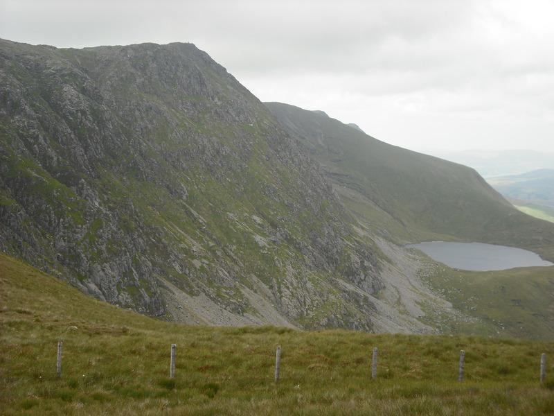
obvious gully to the col below Glasgwm. There are good views northwards over the Rhinogs from here.

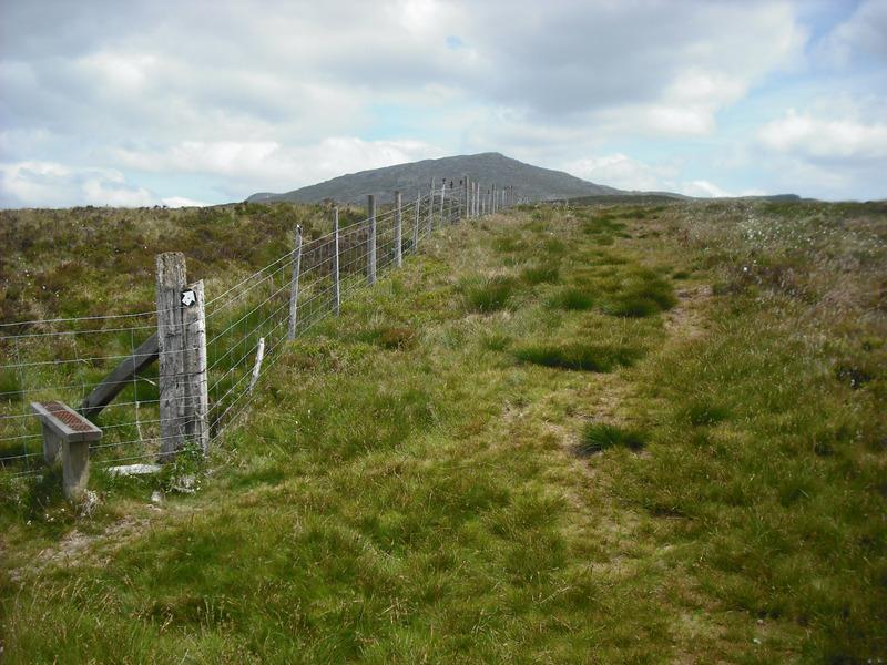
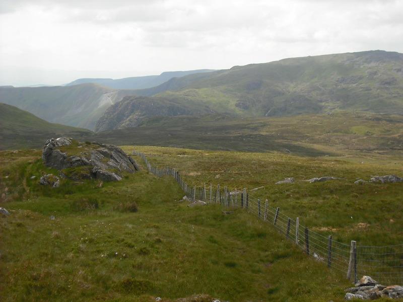
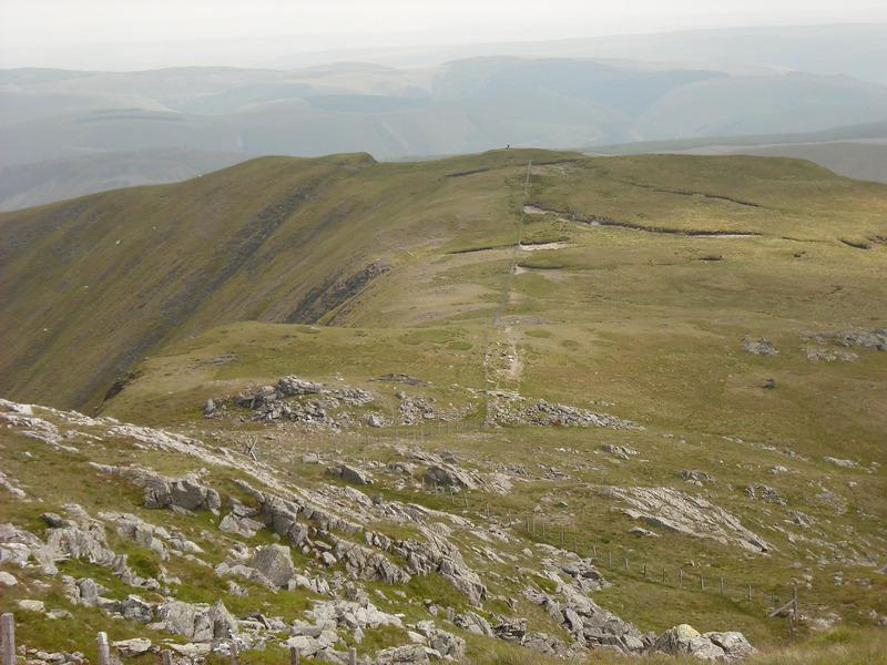
The path now follows the line of a fence, which runs slightly East of North. This area can be very wet and boggy and there are several sections with duckboards. Luckily, after the recent extended dry spell it was almost completely dry and I didn't need the duckboards.

You can see the summit of Aran Fawddwy in the distance. In poor visibility the fence would be a very useful navigational aid. As you approach the summit area, the ground steepens slightly and about half a kilometre from the top a fence comes in from the right. The descent route follows this fence. Note that you cross a couple of other fence before you reach this one.
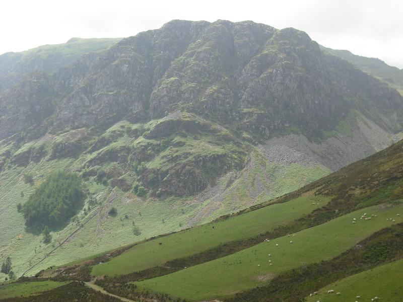
View of the Rhinogs

Finally you emerge on the summit plateau and the trig point is visible 
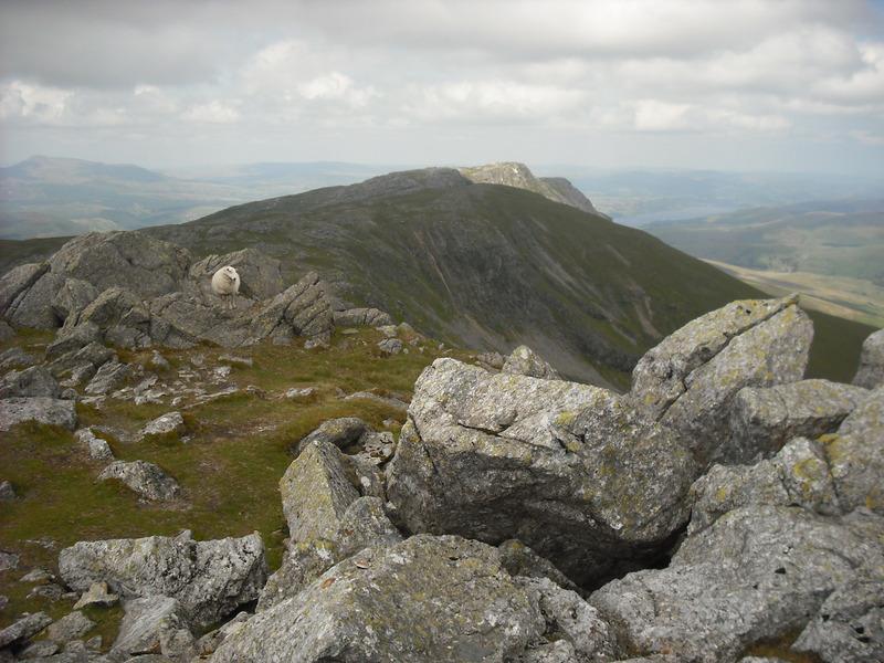
some way in front. The view from the summit is exceptional. Looking North along the ridge over Aran Benllyn, Lake Bala is visible. To the South Cadair Idris stands out and there are views over most of the other peaks of North and mid Wales. Below the steep East face the isolated waters of Creiglyn Dyfi can be seen. To the North East vast areas of boggy moorland surrounding Lake Vyrnwy are visible.

While I was on the summit the wind had picked up, so I put on my Paramo Tores Gilet. I retraced my steps back to the junction of the 
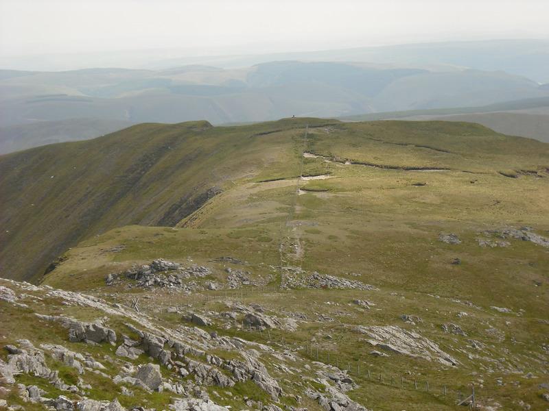
two fences and set off towards the cairn on the ridge above the valley of Hengwm. This commemorates Mike Aspain, a member of the RAF mountain rescue team, who was killed in 1960 by lightning near here. From here the path continues to the summit of Drysgol. There are fine retrospective views of Aran Fawddwy from the whole of this section. The wind had blown in the clouds from the west and the summit of Aran Fawddwy was intermittently disappearing.

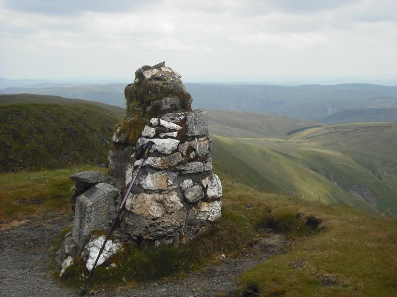
Looking towards the memorial cairn

Once over the summit of Drysgol, I headed downhill towards the col at the base of Waun Goch. From the col there is an obvious path that heads South West along the western slope of Waun Goch, leading back to the road a hundred yards or so from the car park. As I descended the track the cloud over the summits began to disperse again and they were clear by the time I got back to the road.

Apart from the two climbers, I saw only two other people, one near the summit of Aran Fawddwy and one near the bottom of the final descent. I was surprised at the remoteness of Aran Fawddwy. In the good conditions I experienced it was straightforward, but in poor visibility navigating the route would be quite a challange. Although there are paths their relativley uneroded state, given the boggy nature of the ground, suggests that there must be relatively light traffic. I shall definitely be back, possibly on a two day trip, to explore the area better.

Osprey Talon 33 Rucksack

For many years I owned a Karrimor Hot Ice rucksack. Generally, I was very happy with it. However, it did have two slight failings: firstly it was slightly too small and secondly for something called "Hot Ice" it had absolutely rubbish axe attachments. Like all the original sacks made in Accrington it lasted for years.

A few years ago I bought a replacement Karrimor, wich was a tear drop design, with zip closure. I can't remember exactly how much it cost, but it was quite cheap. The materials and construction weren't up to the old Karrimor standard, but given the price, I didn't expect them to be. Recently, the stitching around the zip started to give way and the whole lot began to fray.

I wanted to replace it with something that was large enough to use as a climbing day sack, but could also be used for cycling, or just going for a day walk. I decided that what I wanted was a sack that was around 30 litres, single compartment and not a pear drop shape with zip fastening. There are probably hundreds of sacks that meet this specification, so it took quite a bit of research. I was happy to pay for something that would last, but if it was going to be expensive, I wanted to make sure I liked it!

Finally, I settled on an Osprey Talon 33. One of the things I liked was that it came in a range of back sizes. I am 6ft 2", so generally need a long back size. However, I had read a review on the TGO web site, which although quite positive stated that it was let down by the back being too flexible. I went along to my local branch of Cotswold, who had it in a sale, to try one out. I think that Osprey must have changed the design since TGO's review, since the back on the sack I tried on wasn't at all floppy.

The pack itself is very light (0.92kg according to the data sheet) and although the shoulder straps aren't padded, they seem comfortable enough when carrying a load. The shoulder straps have a couple of small pouches on them, which are apparently for holding energy gels. I can't see me using these, but then they don't weigh much! The back length is adjustable using a velcro attachment system. Easy to adjust, but you will probably only ever use it once. There isn't an internal frame, but there does seem to be some sort of semi rigid back panel, which gives the back some stability. The back panel itself is covered in some sort of mesh, which aids ventilation.

There are a number of tension straps, which make it easy to fold the sack down to carry small loads. There are several small features which make the pack more attractive:

  • Zipped pockets in the hip belt, large enough to hold something like a compact camera.
  • An external bladder pocket. Not much use to me, but nice if you use a bladder.
  • Internal zipped mesh pocket in the lid.
  • External zipped lid pocket, which also contains a velcroed pouch, for things like keys.
  • Captive ends for the adjustable straps to stop them blowing in your face.
  • Nifty web strap under the lid to hold your rope.
  • Stretch front and side pockets.

I have used the sack a few times now and am very happy with it. It costs around £80.

Montane Terra Pants

I wanted to get some trousers which were cool enough for cycling and walking in hot summer weather. I get too hot in my Craghopper Kiwis when cycling in warm weather. Also I have to tuck the ends into my socks to stop them getting tangled up in the chain, as I don't like cycle clips.

The last time I was in Betwys y Coed I saw a pair of Montane Terra Pants in Cotswold. I had read many good reviews of these pants, but as they are expensive I didn't want to buy a pair without seeing them and trying some on. Having tried them on and decided that I like them, I wanted to buy a pair. I wanted a black pair, but Cotswold didn't have any in stock. I searched on line and ended up buying them from Tower Ridge. I bought my Rab sleeping back from them and they have been quick and efficient. The trousers were posted the same day as my order and arrived the next day.

I got a chance to try them out straight away during the current hot spell. I have used them for cycling and as everyday wear for a couple of weeks. Overall I am very happy with them:

Good points.

  • Lightweight and very comfortable. Not too hot in summer, but I shall be interested to see how they fare in the other seasons.
  • Zipped pockets, make it harder to lose your keys or money.
  • Zipped thigh vents, with black mesh underneath, so people can't see my pasty white legs.
  • Zipped bottoms making them easy to roll up, or fit over big boots.
  • Poppers on the bottom of the legs. You can use these to cinch up the ankles, so they don't get snagged in bike chains, or let cold drafts in. You can also roll the legs up and use the poppers to stop them unfolding.
  • Reinforced knee and bum patches.
  • Enough room around the crotch and articulated knees, so good for scrambling and climbing.
  • Smart enough for everyday use.

Bad Points.

  • I am quite tall (6ft 2") and I would like the legs to be a couple of inches longer. They are only available in regular and short leg sizes.
  • Not particularly water resistant. Better then my Craghopper Kiwi's, but anything more than a brief shower will wet them. However, they do dry quickly.

In fact I like them so much, that have just ordered a second pair.

Bryn Tyrch Hotel

When I was a small child, in the 1960's, we often stayed at Cobdens in Capel Curig. The hotel was then owned by a Mrs Newman, who also owned the Tyn y Coed just down the road. I think that she also owned the hotel on the A5 at Pentrefoelas. She lived in the house opposite to Cobdens, by the green bridge over the river. Cobdens was always a bit ramshackle, but in a nice sort of way.

In the 1970's Cobdens had really gone down hill and my parents started to stay up the road at the Bryn Tyrch . By this time I had left home, so didn't stay there with them, but often called to have a meal with them when my weekend trips to North Wales coincided with theirs. Over the years I have drunk countless pints of beer and eaten innumerable bar meals at the Bryn Tyrch. Recently the hotel has been refurbished and the standard and choice of food has been greatly improved. There are still the old photographs, taken by the guidebook author WA Poucher, who use to stay here.

Bryn Tyrch

We have three children and now that they are getting older, we tend not to stay in hotels and guest houses, as we can no longer all fit in one room, so it can work out very expensive. However, it turns out the Bryn Tyrch has a couple of bunk rooms inside the hotel, which meant that we could fit in one room and the children had a room to themselves. The food was excellent, importantly there were things that the children would eat available in child size portions.

The standard of the rooms was very good, with excellent breakfasts. The staff are also family friendly and the price for B&B for all five of us very reasonable. The location of the hotel in Capel Curig is ideal for visiting all parts of Snowdonia. In fact you can start many walks from the hotel itself, so you don't have to drive at all. I am sure that we shall be staying there again.